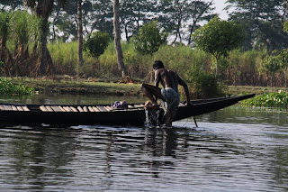
The daily reality of some 400,000 people in southwestern Bangladesh is far different than the one most of us live out. For over half the year dire water-logging, caused by human error, leaves thousands of people's lands and homes underwater. Centuries of river management have left many of Bangladesh's most poor and under-represented to fend for themselves.
Yearly floods affect the businesses, health, education, and livelihoods of six regional sub-districts under the larger Satkira (pronounced Shatkira) and Jessore (Jeshshore) districts. Some help is given. However, assistance is limited in relation to demand.
The first few days of this past week were dedicated towards taking part in a VSO conference on good governance (coincidentally at one of Uttaran's training centers). The rest of my week though was spent learning about the types of communities Uttaran is working with. Two of my days in Khulna were spent driving down countless narrow dirt roads drinking flat soda and taking pictures of camps, towns, and acres and acres of water-damaged land affected by the flooding. My Uttaran counterparts were gracious to give me such a "tour". As one of them so memorably said while driving home one evening "this is Bangladesh".
In some cases the flood waters cover over key transport roads. Often the nearest way around may be some 25 kilometers, down narrower roads, out of the way. Why does such an event happen? The simplest explanation is because of years of national and international river management. Starting near the Bay of Bengal, and moving further inland, are a series of dams, canals, and embankments. Water was, and continues to be, diverted and blocked in strategic places across the southern region of the country. Part of the reasoning is to control the river for safe travel and the other to create more farmland.
Over time though silt, essential to creating and stabilizing land on the coast, is left to deposit on the river banks. As years pass river banks grow higher and the land around it becomes lower. Take into account heavy monsoon rains in the summer and you achieve mass flooding.
To learn more about the history of river management in Bangladesh I suggest you look into the following websites:
I have uploaded all of my pictures from this past field visit. You can access them either by clicking here or via the right-hand sidebar link FP Pics.
Calling what is happening here an "issue" is unfair. Categorizing and labeling situations like water-logging as "problems"or "issues" is to place them in a vacuum - alone, over there, out of reach. Reality however does not live in a vacuum. Neither does inhumanity or survival.
No comments:
Post a Comment